Advanced GIS Joint Laboratory: Joint Research laboratory in partnership with ESRI Italia
The lab aims at developing innovative projects within the framework of geospatial application for training programmes, education, as well as the safeguarding, management and promotion – even for tourism – of cultural heritage and of the territory in general.
Its ultimate goal is to respond to the needs to integrate the knowledge, competence and methodologies of geographic and geospatial research in those fields, also by fostering its role as a research laboratory committed to the knowledge-sharing towards the production of localized information and the implementation of tools enabling the accessibility to geographic data.
AGJL Targets
Development of research projects and common strategies for the dissemination of methodologies and tools for geographical analysis with particular regard to the education and training (formal and informal) sector, and to sectors pertaining the tourism and cultural and natural heritage
Dissemination and utilization of geospatial technologies within primary, secondary and higher education and in lifelong learning programmes
Sharing know-how and tools for the production of localized information and the implementation of tools for accessibility to geographical data with particular attention to the functions of governance and management of the territory, to the promotion of cultural heritage and the anthropic landscape, and to support for entrepreneurial strategies
Creation of teaching units for primary and secondary schools through the tools of the ArcGIS Online platform in all areas likely to use geospatial data with particular focus on geography, history and issues related to cultural heritage and the anthropic landscape
Promotion of projects (funded or co-funded) for sharing geographic information through cloud tools and mobile technologies, aimed at creating specific crowdsourcing-based geographic data sharing environments
Establishment of a reference center within the University of Florence to provide support and advice to departments and research groups wishing to use ESRI GIS technologies
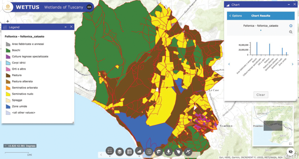
Online publication of quality georeferenced cartography for the Italian territory, through the ArcGIS Online platform
Development and publication of thematic atlases using ESRI technologies
Support and promotion of the “Istruzione Tecnica Superiore (ITS)” courses – Higher Technical Education (post-diploma courses) – of the Tuscany Region as regards the GIS components
Organization of training activities related to life-long professional learning